
Tzu-Hsin Karen Chen, a visiting PhD student at IGN and her co-supervisor Ass. Prof. Alexander Prishchepov have published a new article about three-dimensional urban form monitoring using a semantic segmentation framework and Landsat time series analysis. See the full publication in Remote Sensing of Environment: https://authors.elsevier.com/a/1bnBl7qzSr7Gv
Urban land cover grows at the fastest rate amongst all kinds of land cover globally. Not only does urban expansion influence the environment by competing with other land covers, but the fabric and form of the urban realm also shape people’s daily experiences and mental well-being: perceived temperature, air quality, commercial and recreational activities, and landscapes and spaces, which provide a sense of belonging, stress or stress-relief.
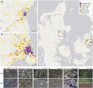
Geoinformation of urban form – i.e. the size, density, height of the built environment – is essential to evidence-based policies for sustainable development. However, monitoring three-dimensional morphology with remote sensing technology has been challenging, as the major civilian satellite time series, Landsat, has been settled with 30 m spatial resolution, which is larger than many urban objects. Unfortunately, widely used scene recognition techniques such as convolutional neural networks (CNNs) tend to sacrifice the spatial resolution from the input data (e.g., 30m Landsat inputs become 100m urban form maps) during pooling and convolution computing.
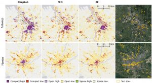
The study in collaboration with German Aerospace Center (DLR) provides a semantic segmentation framework that could save the resolution loss, which is ’unaffordable’ for Landsat-based urban mapping. The authors compare three popular and emerging methods, DeepLab, fully convolutional networks, and random forest.
Here is the highlight:
-
Overall, DeepLab is the most accurate model if using a large dataset (i.e., about 70% of Danish cities were used for training). Otherwise, FCN shows an advantage for smaller datasets.
-
DeepLab can better differentiate high-rise buildings with different backgrounds (e.g., an outlet in the suburbs or high rises in the downtown) when the multi-scale features are tuned appropriately.
-
Transferability: DeepLab > FCN >> RF. The assessments include temporal transferability (apply the model trained on one-year data to other years) and spatial transferability (apply the danish model to other European cities).
Use time-series Landsat from 1985 to 2018, this study reveals different strategies to feed the growing population: while Aarhus (second largest city) has been densifying horizontally, the Copenhagen suburbs have been growing up. Therefore, we expect that capital accumulation will continue to diverge between the danish capital and other medium and small cities.
More details about the proposed framework and assessments are available from the preprint.
This post is originally published at Karen’s blog.